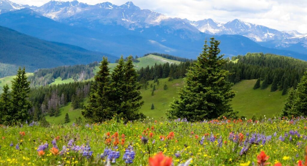
Travelers with dreams of hiking and even wading through fields thick with wildflowers are in luck! Colorado meadows and mountainsides explode with color each summer when the flowers are in bloom, offering scenery and photo ops galore.
Although wildflowers can be spotted nearly everywhere, even the highway medians, hiking is the best way to experience these natural beauties. Hikers have plenty of time to admire an impressive variety of flowers coupled with waterfalls, lakes, and mountain landscapes.
When to see wildflowers
Peak bloom at higher elevations like the Vail Valley and surrounding area is in early July to mid August, although the wildflowers are still impressive a few weeks on either side.
What kind of wildflowers will hikers see?
There are dozens of wildflowers hikers may spot on their trek. Some common types are: Indian Paintbrush, Bluebell, Sego Lily, Larkspur, and Lupine. Keep an eye out for Colorado’s state flower, the white and lavender Columbine, pictured below. These unique flowers are most often found in pink, purple and blue in the Vail Valley but come in dozens of colors.
Colorado Wildflower Guide

Where to find wildflowers
Wildflowers can be found in any natural, unmanicured environment in the Colorado Rocky Mountains during most of July and part of August.
They are often found in higher concentrations in meadows and hillsides deeper in the woods, which is why hiking is an excellent way to get your fill.
Many flowers thrive in sunny, cooler, alpine environments but lots are adapted to varying conditions.
Leave no trace
Remember, leave nothing but footprints and take nothing but memories. Wildflowers might be tempting to pick but it’s important to leave them be so they can support Colorado’s ecosystem.
TRAILS
Try these trails for a dose of nature filled with wildflowers.
Keep in mind there are a number of trails with easy access right on Vail and Beaver Creek mountains. However, a bit further of a journey rewards travelers with unique views and often a higher concentration of wildflowers.
Shrine Ridge
Distance: 4.3 miles
Trail Type: out and back
Driving Time from Vail: 24 minutes, 16.7 miles
Difficulty: moderate-difficult
Elevation Gain: 1,030 feet
Dogs Allowed?: Yes, on leash.
Highlights: nearly 360 degree views at the top!
Local Tip: A great hike for most levels of hikers and easily accessible from Vail and I-70. Hikers can catch some breathtaking sunsets at the top of the ridge but should check the weather and be prepared with headlamps for the hike back down.
Trail Map
Upper Piney River Trail
Distance: 5.9 miles
Trail Type: out and back
Driving Time from Vail: 42 minutes, 12.3 miles
Difficulty: moderate
Elevation Gain: 728
Dogs Allowed?: Yes, on leash.
Highlights: Gore Range views and shady aspen groves
Local Tip: Most cars with high clearance can handle the dirt road but we suggest an SUV, preferably with AWD. The road can be a bit bumpy and rutted out. Hikers who make it to the lake around daybreak are likely to spot a few moose!
Trail Map
Notch Mountain via Fall Creek
Distance: 9.6 miles
Trail Type: out and back
Driving Time from Vail: 48 minutes, 18.5 miles
Difficulty: hard
Elevation Gain: 2,857 feet
Dogs Allowed?: Yes, on leash.
Highlights: expansive mountain views of the Gore Range, Sawatch Range, multiple 14ers including Mount of the Holy Cross
Local Tip: Parts of this trail are above tree line, meaning direct sun exposure. Pack sunscreen, shades, and a hat.
Trail Map
Missouri Lakes
Distance: 9.2 miles
Trail Type: out and back, can be connected to the Fancy Pass loop
Driving Time from Vail: 52 minutes, 27.9 miles
Difficulty: hard
Elevation Gain: 2,322 feet
Dogs Allowed?: Yes, on leash.
Highlights: lots of water features including waterfalls, a river, and multiple lakes
Local Tip: Bring a fishing pole and fishing license; the bass is plentiful in the larger lakes!
Trail Map
Vail Mountain Gondola
For those who are short on time or unable to tackle a long hike, a scenic gondola ride up Vail Mountain can deliver them to the wildflowers. Flowers can be found scattered throughout the peak area of Vail and on many trails. Opt to take a trail like Berry Picker down the mountain, which would be just shy of 4 miles and a decline of 2,286 feet in elevation.